
ABOUT THE PROJECT
Farmers make critical operational decisions every day — spraying, seeding, harvesting — but these decisions depend heavily on weather. Existing tools provided raw forecasts, but they were hard to interpret for real farming decisions, especially under time pressure.
I led the design of a Weather & Risk Prediction Tool that translates complex weather data into clear, actionable insights, building trust and confidence in decision-making.
I led the design of a Weather & Risk Prediction Tool that translates complex weather data into clear, actionable insights, building trust and confidence in decision-making.

THE PROBLEM
Can I safely act now?
Mental Calculation Under Pressure
Generic forecasts forced farmers to mentally calculate risk in the field, while operating machinery — a process that took time they didn't have.
High Cost of Misinterpretation
A wrong spray decision due to sudden wind or humidity shifts could mean crop damage, wasted expensive inputs, or missed narrow operational windows.
App Fragmentation
Growers relied on 2–3 separate apps to cross-verify forecasts before making a single field decision — slowing down every call they made.
Data Without Context
Current tools displayed raw charts with too many parameters and no clear "go / no-go" guidance — showing information, not decisions.
PRIMARY USER
Meet Mark
“I don’t need more weather data. I need to know if I can spray.”
Age: 47
Farm Size: 3,200 acres (grain & oilseed)
Tech Comfort: Moderate
Devices: iPhone + in-cab tablet
Decision Style: Fast, experience-driven
GOALS
Maximize spray efficiency
Avoid crop damage
Minimize wasted inputs
Reduce operational delays
Quick, glanceable info
FRUSTRATIONS
Apps lack field-level specificity
Forecasts change without explanation
Checks 2–3 apps per decision
No time to interpret raw data
Charts while in a cab
Biggest Fear: Making a wrong spray decision due to a sudden wind or humidity shift that wasn't flagged clearly.

Research Strategy
What I Heard in the Field
8
One-on-one farmer interviews with FieldClimate users managing spray, seeding, and fertilization ops
3
In-field ride-alongs to observe real-time decision-making under actual field conditions and time pressure
Competitive benchmarking of weather and ag tools to map where existing solutions were failing growers
Key Interview Insights
Farmers Don’t Trust a Single Source
Farmers often Check multiple apps for peace of mind, Compare forecast vs. station data, Walk fields to confirm moisture.

Speed Matters More Than Depth
Farmers check weather while operating machinery. They don't pull over to analyze charts. They need instant answers mid-task. Depth of data is useless if it can't be scanned in three seconds.
“I need to quickly open something and make a decision.”
Weather Is Used to Answer Specific Questions
Farmers aren't browsing weather for interest. They want answers:
"Did it frost last night?“
"Is wind getting worse? “
"Should I spray right now?“
"When is my next window?“
But current apps showed raw charts, too many parameters, and no go/no-go guidance.
Current Farmer Workflow (Before My Design)

The Solution
To address the fragmented and high-stress way growers currently access weather data, I designed an integrated Weather & Risk Prediction system within Croptivity that transforms raw forecast and station data into clear, operational risk indicators.

The solution translates weather inputs into contextual signals such as Spraying Risk levels, optimal activity windows, accumulated rainfall summaries, and confidence scores.
By embedding these insights directly into field scheduling workflows and surfacing only the most relevant parameters at the moment of decision, the system:
Reduce Cognitive Load
Improves Speed to Decision-making
Builds trust through transparent data sources
Ultimately helping growers act with greater confidence and lower operational risk.
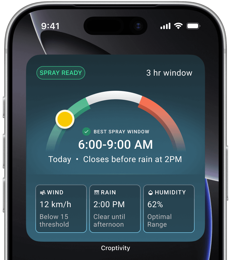
Operational Risk Indicators
A Risk-Based Indicator System That Thinks Like a Farmer
Farmers don't think in wind speed and humidity percentages. They think in actions: Can I spray? Should I wait? Will frost damage crops?
So instead of displaying isolated weather variables, I designed a system that aggregates multiple weather inputs into clear operational signals — removing the need for mental calculation.

Why This Matters: Previously, farmers checked 2–3 apps, interpreted line charts, estimated wind drift risk manually. Now they see a single signal aligned with their task.
This shifts the product from “information tool” to “decision support system.”
Time-Based Operational Windows
Designing Around How Farmers Actually Plan
Through interviews, I learned that farmers don't think in daily forecasts.
They think in windows: "Can I spray this morning? Will wind drop after lunch? Should I finish this tank?"
I introduced Risk Timeline Views showing risk states across hourly or 3-hour segments letting growers scan an entire day in a single glance.
Why This Matters: This allows farmers to optimize their workday, plan labor more effectively and finish tasks before conditions deteriorate.
It supports proactive planning instead of reactive shutdowns.


Map-Based Weather Intelligence
Farmers Think Spatially — The Interface Should Too
This screen visualizes all weather stations directly on the field map, allowing growers to instantly compare real-time conditions across locations. Station markers display live data callouts, removing the need to mentally connect station names to physical fields.
Smart Parameter Filtering with filter chips lets users toggle which metric appears on the map — keeping the interface focused and task-specific.
Why This Matters: Weather conditions can vary significantly across large acreages. By presenting filterable data directly on the map, the system reduces cognitive load and enables faster, more confident decisions in the field.
Weather Details & Forecast
Operational Weather Intelligence in One Unified View
A complete, real-time snapshot of a selected weather station — combining current conditions, soil data, and forecast insights into a single actionable dashboard.
The integrated multi-day forecast and historical weather data enable both short-term scheduling and long-term planning — decisions informed by what's happening now, what's below the surface, and what's coming next.
Why This Matters: By consolidating atmospheric conditions, soil sensor insights, and forecast data, this screen reduces the need to interpret scattered metrics across multiple tools — connecting above-ground and below-ground conditions to real operational decisions.

Business Impact
Outcomes That Matter
FOR GROWERS
Faster decisions — from multi-app ritual to single glance
Reduced spray drift risk through clear go/no-go signals
Increased confidence in field-level forecasting
Less app switching — one trusted source of truth
Better seasonal planning through historical data access
For Decisive Farming
Weather intelligence fully integrated into Croptivity
Increased platform stickiness through daily habit loops
Upsell opportunity to Premium weather tier
Competitive differentiation vs. The Weather Network
Positions Croptivity as a full operational planning platform
What's next
If I Were to Build This Today
The foundation we shipped (risk indicators, operational windows, map-based station intelligence) was the right first layer. It moved the product from information tool to decision-support system. But with where AI is now, the next evolution isn't about adding more data. It's about removing more thinking.
Natural Next Steps
The most immediate opportunity is closing the last gap between data and action: telling Mark not just what the conditions are, but what to do and when.
From dashboard to daily briefing
The risk timeline we shipped requires Mark to open the app, scan the day, and spot the green window himself.
The next step is inverting that. The app does the scanning & surfaces the answer before he even asks. Same mental model, same trust foundation, AI just removes the remaining cognitive steps between data & decision.
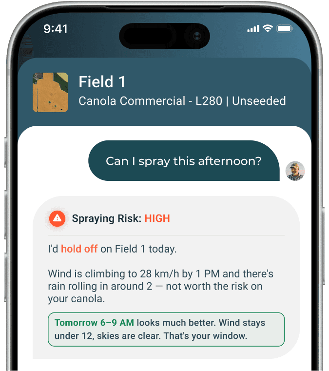
Natural language Q&A
This addresses the core research insight that farmers check weather mid-task, often while operating equipment.
Instead of navigating screens, Mark could simply ask: "Can I spray this afternoon?" and get a direct, contextual answer. The interface becomes a conversation, not a tool.
Pushing Further
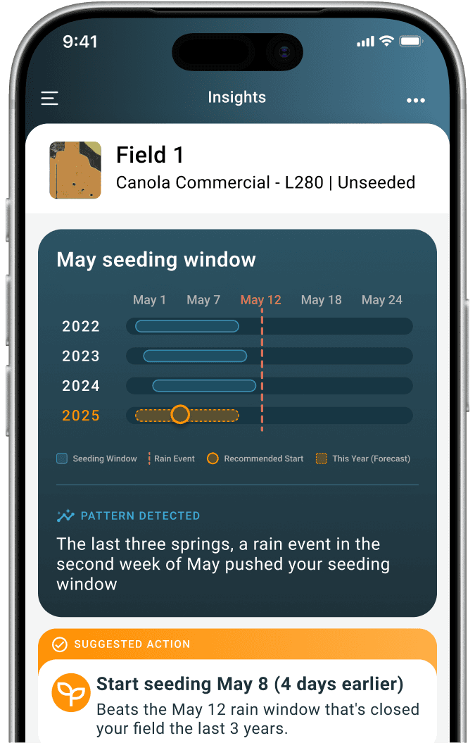
The longer-term vision is an app that learns the farm, its fields, its history, its patterns, and starts surfacing intelligence that no weather service could ever provide.
Seasonal Pattern Learning
The app would combine historical weather data with the farmer's own activity logs to surface proactive guidance:
"The last three springs, a rain event in the second week of May pushed your seeding window. This year's forecast looks similar, consider starting four days earlier."
That's not a forecast. That's institutional knowledge, automated.
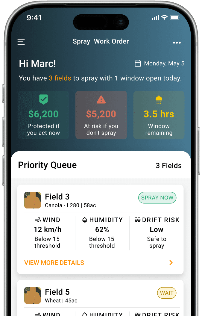
Multi-field Priority Queuing
Instead of "High spray risk due to wind,"
Mark sees: "Spraying now could waste up to $3,800 in product due to drift."
Wind speed is data. $3,800 is a decision. When the app speaks in dollars, it stops being a weather tool and starts feeling like a business partner.
Next Case Study
VIEW CASE STUDY
